
Yesterday I put forth my wish on IRC to see work on this region, when we've finished what we need around Karthwasten as well as the Druadach Highlands. Getting some actual releases out should be top priority right now, especially as they're within reach (no pun intended!).
As we could get away with this region being quite barren, I think we should consider focusing some work in this direction, as it would be more quickly finished than most other immediate regions. It would make a great opportunity to finally have the entire westernmost part of Skyrim finished off, instead of having patches here and there.
Here's my initial vision when I picture the region:
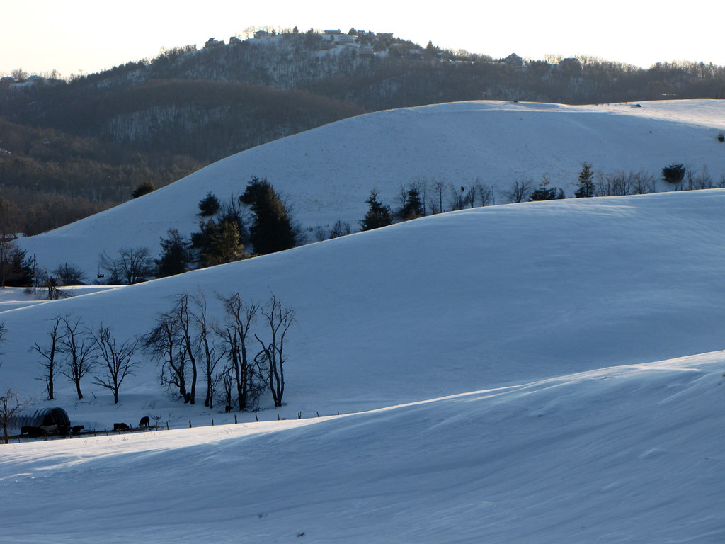
- The area north and west of Falkirstad consists of snowy hills with sparse vegetation, with some dead_grass areas. An almost tundra-like landscape, with a few nomadic Reachmen camps and a Breto-Nord fishing village or two. Pines grow in number when you travel east, and dwindle when going west. The area is home to many elk and deer herds, hunted by Nords and Reachmen. We could put some wetlands (like in Worsas' canyon, but icy) at the foot of the hills.
- Besides the promixity to Falkirstad (located in the neighbouring Falkar Foothills region) there shouldn't be many points of interest. There are a few however; the legion fort guarding the Western Reach border is also the place where King Barda's youngest son is learning generalship. A few fishing villages (I'm thinking two 2-3 houses and one 4-5) with some cultural mixing between Skyrim and High Rock, some of them could be whalers. The Reachmen camps should consist only of small huts and give a clear impression that they're moving around with the herds. I think it will be interesting to see the Reachmen set in a snowy setting.
- Now that the mouth of the Karth river will be moved south of Haafingar, I propose the place where the river used to be to be made into a rocky ascent, shielding the Solitude Forest, ending in the south with the unnamed mountain at the north of the lake. If we could make the coastline north of haafingar dominated by cliffs and height, it would put the Solitude Forest and most of Haafinheim Hold in a remote semi-valley, adding to it's isolated "solitude"-character. Just a suggestion. A few First Era Nord fortifications would be found in these cliffs.
Region Planning: "Northern Coastline"
Region Planning: "Northern Coastline"
- Attachments
-
"I don't know if you are kidding but I 100% support a Big Mouth Billy Bass in PC"
- Taniquetil
- Taniquetil

I would, indeed, like to see a more hilly and less rocky landscape, slightly similar to what you've got on Solstheim.
Since the western part is essentially the Western Reach, it would make sense to see a single Direnni ruin, at least. We could name that area 'Haafinheim, Northern Reach'.
According to our Ordo Legionis, Fort Northwatch should be added to this area. We could use the Imperial Fort that is already in the landmass file.
Could we make the region semi-snowy, with a greenish stripe towards highrock, but increasing snow coverage towards Haafinheim and northern coast?
Edit: I imagine the northern beach to feature a dark gravel ground (therefore the name Obsidian Coast on the highrock map). The way I imagine it, pretty much a beach using "Tx_Skyrim_Gravelroad_01" in place of Sand.

I really like the idea of a dark-sand type beach. I trawled up some semi-snowy beaches for inspiration:
[hsimg=]http://i.imgur.com/hBjD7Ez.jpg[/hsimg]
[hsimg=]http://i.imgur.com/kWG2x4R.jpg[/hsimg]
[hsimg=]http://i.imgur.com/pyBpsG0.jpg[/hsimg]
Number 3 seems to me what we should be aiming for moving along the coast toward Haafinheim.
[hsimg=]http://i.imgur.com/hBjD7Ez.jpg[/hsimg]
[hsimg=]http://i.imgur.com/kWG2x4R.jpg[/hsimg]
[hsimg=]http://i.imgur.com/pyBpsG0.jpg[/hsimg]
Number 3 seems to me what we should be aiming for moving along the coast toward Haafinheim.
<roerich> woah it's hot in here
<Lord Berandas> it must be Summer.
<Infragris> #hell is meant as a spam and off topic channel. Doing a great job already
<Lord Berandas> it must be Summer.
<Infragris> #hell is meant as a spam and off topic channel. Doing a great job already
@Worsas
Gravel sand and gradual thaw towards High Rock sounds perfect to me.
Hmm, Northern Reach sounds a bit too bland to me. I hope we can come up with something else, either continue the Obsidian Coast or something new.
@Luxray
Nice pictures. Indeed close to how I imagine it.
Edit: Found some more inspirational pictures. Googling "black beach" gave some good results as well as a surprising amount of nude pictures (on said beach, though).
[hsimg=]https://upload.wikimedia.org/wikipedia/ ... _Black.JPG[/hsimg][hsimg=]http://creekmoreworld.com/wp-content/up ... land-2.jpg[/hsimg][hsimg=]http://www.nature-pictures.info/wp-cont ... ches-5.jpg[/hsimg]
[hsimg=]https://c1.staticflickr.com/5/4072/4392 ... 6632_b.jpg[/hsimg][hsimg=]http://s2.thingpic.com/images/a7/4WY4Mp ... dAUJT.jpeg[/hsimg][hsimg=]https://www.polartrec.com/files/members ... sc0962.jpg[/hsimg]
Gravel sand and gradual thaw towards High Rock sounds perfect to me.
We should have a Direnni port fortress, half sunken into the sea. The sunken part of the ruins containing some good treasure, the land part being mostly looted. Currently occupied by sea-faring reavers, raiding merchant ships passing by. Built on or next to a large sea cave, where the longships are hidden. The local legion fort could have a quest to find and terminate these bandits.worsas wrote: Since the western part is essentially the Western Reach, it would make sense to see a single Direnni ruin, at least. We could name that area 'Haafinheim, Northern Reach'.
Hmm, Northern Reach sounds a bit too bland to me. I hope we can come up with something else, either continue the Obsidian Coast or something new.
@Luxray
Nice pictures. Indeed close to how I imagine it.
Edit: Found some more inspirational pictures. Googling "black beach" gave some good results as well as a surprising amount of nude pictures (on said beach, though).
[hsimg=]https://upload.wikimedia.org/wikipedia/ ... _Black.JPG[/hsimg][hsimg=]http://creekmoreworld.com/wp-content/up ... land-2.jpg[/hsimg][hsimg=]http://www.nature-pictures.info/wp-cont ... ches-5.jpg[/hsimg]
[hsimg=]https://c1.staticflickr.com/5/4072/4392 ... 6632_b.jpg[/hsimg][hsimg=]http://s2.thingpic.com/images/a7/4WY4Mp ... dAUJT.jpeg[/hsimg][hsimg=]https://www.polartrec.com/files/members ... sc0962.jpg[/hsimg]
"I don't know if you are kidding but I 100% support a Big Mouth Billy Bass in PC"
- Taniquetil
- Taniquetil
At some point the plan for this area was to make it the Cascabel County from Rear Guard. That would mean that we have to add Cascabel Hall aswell, though.Hmm, Northern Reach sounds a bit too bland to me. I hope we can come up with something else, either continue the Obsidian Coast or something new.
Moved to Haafingar (Haafinheim?) subforum. All hail King Thian.
"I don't know if you are kidding but I 100% support a Big Mouth Billy Bass in PC"
- Taniquetil
- Taniquetil
Nope, not yet. The transition zone next to Mt. Snowhawk is a good indicator of the palette and suitable meshes.
http://i.imgur.com/zgdxdWh.png This is roughly how I imagine the heightmap of this region. I have added a proposal for a new mountain, smaller than Snowhawk and Draukar. It would help isolate the Solitude Forest among other things.
[Moved from viewtopic.php?f=124&t=654" onclick="window.open(this.href);return false; -roerich]
"I don't know if you are kidding but I 100% support a Big Mouth Billy Bass in PC"
- Taniquetil
- Taniquetil

Looks great. Didn't we agree on pasting my Reachman village on the road between Amrothal and Markarth too, though? That's certainly the most sensible of discussed locations.
I also thought we eventually decided to place Cascabell Hall SE of Markarth. I'd swear I even saw an apple grove somewhere there in your most recent Markarth file. I vaguely remember a talk about Cascabell sounding Breton enough to place the castle here, closer to High Rock, though... To be honest, on the other hand I'm not sure the climate here would even allow apples to grow; unless we're discarding/adjusting that bookstory?
I also thought we eventually decided to place Cascabell Hall SE of Markarth. I'd swear I even saw an apple grove somewhere there in your most recent Markarth file.
We decided placing your village between the finished mesa west of DS and the one in this claim. It makes the most sense for it to be relatively secluded and rural. If we add a village on the road discussed, it should be a small nordic frontier farmer settlement.
The idea of Cascabel being situated SE of Markarth was also quickly dismissed. The apple story is probably the work of an imaginative author.
Edit: I would also propose removing one or two fishing villages, so there's only the one near Fort Northwatch and the cove near Dunbarrow, and perhaps the westernmost one directly north of Karsknhal. The road to Fort Northwatch should be very badly maintained (transport and supplies should primarily go through sailing), and more like a path than an actual road. It should also go east, following the coastline, instead of south, joining with the roads near Dunbarrow. All of this would help making the region more wilderness like and rural. Between Fort Northwatch and Karsknhal, one should only encounter Nomadic Reachmen and wild beasts.
The idea of Cascabel being situated SE of Markarth was also quickly dismissed.
Edit: I would also propose removing one or two fishing villages, so there's only the one near Fort Northwatch and the cove near Dunbarrow, and perhaps the westernmost one directly north of Karsknhal. The road to Fort Northwatch should be very badly maintained (transport and supplies should primarily go through sailing), and more like a path than an actual road. It should also go east, following the coastline, instead of south, joining with the roads near Dunbarrow. All of this would help making the region more wilderness like and rural. Between Fort Northwatch and Karsknhal, one should only encounter Nomadic Reachmen and wild beasts.
"I don't know if you are kidding but I 100% support a Big Mouth Billy Bass in PC"
- Taniquetil
- Taniquetil
-
Scamp

- Lesser Daedra
- Posts: 465
- Joined: Sat Jan 03, 2015 2:51 pm
- Location: Kilkreath Mountains
- Contact:
Alright, nice work on the heightmap. We'll have to see if we can pull off your new mountain proposition in a believable way. Though - if it's smaller in height than Snowhawk I assume it will blend well with its surroundings, but then again it'll most likely be a large hill rather than a mountain.
http://i.imgur.com/1Tw6Zap.png
Scale's a bit off, but here's a rough interpretation of the location of the new mountain and how it would interact with the surrounding landscape.
"I don't know if you are kidding but I 100% support a Big Mouth Billy Bass in PC"
- Taniquetil
- Taniquetil
Moved the posts to a more relevant location.
"I don't know if you are kidding but I 100% support a Big Mouth Billy Bass in PC"
- Taniquetil
- Taniquetil
That's great! Perfectly fine with me.
Thinking about it again, I think it would make sense to have a cliffside between Cascabell and mesa #3, atop of Caiar Druad canyon. Cascabell Hall used to belong to High Rock, and that way we'd have an old natural border of a sort between provinces in the West, how we already do in the South: Vordngad Forest/river Karth (both between Karthgad-Lorchwuir and Beorinhal-Lorchwuir)/cliffs of Druadachs. I sketched how the cliff could look like in green here: http://i.imgur.com/sblOymD.png South of that cliffside there can be a run-down dirt path passing through Caiar Druad marshes and then climbing up the mesa as well, a less traversed extension of Markarth-Falkirstad main road, going from the crossroads, like Haimtir road branches out from Dragonstar way. I'm not insisting on that one, though.
Thinking about it again, I think it would make sense to have a cliffside between Cascabell and mesa #3, atop of Caiar Druad canyon. Cascabell Hall used to belong to High Rock, and that way we'd have an old natural border of a sort between provinces in the West, how we already do in the South: Vordngad Forest/river Karth (both between Karthgad-Lorchwuir and Beorinhal-Lorchwuir)/cliffs of Druadachs. I sketched how the cliff could look like in green here: http://i.imgur.com/sblOymD.png South of that cliffside there can be a run-down dirt path passing through Caiar Druad marshes and then climbing up the mesa as well, a less traversed extension of Markarth-Falkirstad main road, going from the crossroads, like Haimtir road branches out from Dragonstar way. I'm not insisting on that one, though.
-
Scamp
- Lesser Daedra
- Posts: 465
- Joined: Sat Jan 03, 2015 2:51 pm
- Location: Kilkreath Mountains
- Contact:
I quite enjoy your magnificent sketches, roerich. They give a decent boost to my imagination of the area.
I'm not sure about the road berry proposes actually branching into the mesa - every road needs to have a meaningful endpoint in each direction it goes, and I don't see what's worth connecting on this rather desolate mesa.
I'm not sure about the road berry proposes actually branching into the mesa - every road needs to have a meaningful endpoint in each direction it goes, and I don't see what's worth connecting on this rather desolate mesa.
The "road" is maybe saying too much for what I had in mind. More like some patches of grassless dirt, vaguely creating a shape of a road, with some subtle vertex painting. Maybe some shallows of water to cross in the canyon part, too. Something like what we already have by the feet of Karthgad's mesa (joining Bear Clan barrow with KG's wooden stairs) or in front of a ruined Redguard fort south of Karthwasten.
Still, I'm not exactly sure about it myself either, especially since Reachmen (Haimtir and Old Hroldan being the only exception so far) in general don't get roads leading to their settlements, and settlements on this mesa are supposed to be even more nomadic.
Still, I'm not exactly sure about it myself either, especially since Reachmen (Haimtir and Old Hroldan being the only exception so far) in general don't get roads leading to their settlements, and settlements on this mesa are supposed to be even more nomadic.
I'd say no to roads in these wild regions.
Regarding the cliff, I was imaginening Cascabel being situtated on a cliff overlookning a valley of sorts between Cascabel and the Caiar Druad mesa valley. I'm not sure an extra cliff here would achieve anything, but it wouldn't hurt either, if it's roughly the same as my heighmap.
Regarding the cliff, I was imaginening Cascabel being situtated on a cliff overlookning a valley of sorts between Cascabel and the Caiar Druad mesa valley. I'm not sure an extra cliff here would achieve anything, but it wouldn't hurt either, if it's roughly the same as my heighmap.
"I don't know if you are kidding but I 100% support a Big Mouth Billy Bass in PC"
- Taniquetil
- Taniquetil